Weather: Dangerous Drops
Frozen on arrival

We know that water can exist in three forms: a solid, a liquid, or a gas (water vapor). Cloud droplets fit the liquid state, but special dynamics occur when temperatures are below freezing. That’s when droplets are at a freezing temperature, yet remain liquid. The droplets are said to be supercooled. These supercooled droplets bounce around within a cloud, hit each other, and merge to form larger droplets. The size of the droplets depends on the liquid water content (LWC) of the cloud, temperature, and air pressure—which roughly corresponds to altitude.
Sopping wet cloud masses—the sort you’d find in well-developed cold fronts, or near the Pacific Northwest, Great Lakes, or New England—typically have larger droplet sizes and higher LWC. Weather that’s less influenced by large bodies of water, or less active weather fronts, tend to have smaller droplet sizes and LWC. It’s the bigger droplets and LWC that cause the most dangerous, clear icing conditions. The droplets are so large that they can hit an airplane’s leading edges, run back on an airfoil, and then freeze solid. They can even splatter and quickly create large, drag-producing shapes. Smaller droplets with less LWC produce rime ice accretions that grow more slowly, and flash-freeze on impact, trapping miniscule air bubbles within them. It’s those air bubbles that give rime ice its white appearance. But rime icing is every bit as dangerous as the clear variety. If you fly long enough in any icing condition, even light buildups will reach moderate to severe levels. That’s why it’s important to avoid icing conditions or leave them as soon as they’re detected.
Yes, manufacturers can certify airplanes for flight into known icing (FIKI) conditions. To do that, they have to prove that airfoil leading edges, propellers, windshields, pitot tubes, and other critical airframe parts can be kept free of icing. However, inflatable leading-edge deice boots and heated propellers, windshields (see “How It Works: Seeing Your Way Clear,” page 15), and pitot tubes can’t be trusted to spare you from the effect of large buildups. They just buy you some time to carry out an escape.
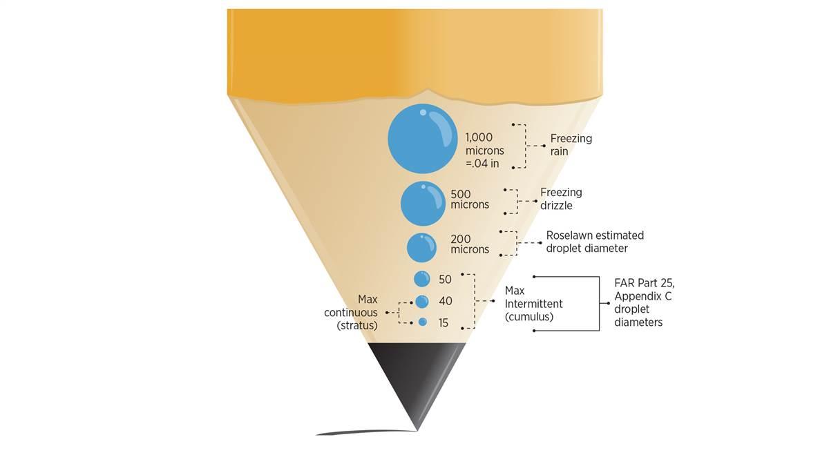
Certification standards define droplet sizes and LWC. Cumulus clouds with large droplets and having diameters between 15 and 50 microns, and LWC between 0.5 and 3 grams per cubic meter—that’s a recipe for clear ice. Stratus clouds standards are 15- to 40-micron droplet diameters and 0.2 to 0.8 grams per cubic meter LWC. Those are small droplet sizes, but the higher cumulus LWC values mean clear ice, while the lower stratus LWC values make all the difference.
What about snow and freezing rain? Snow happens when droplets form around microscopic condensation nuclei—like suspended dust, dirt or other particles—and crystallize. Freezing rain amounts to clear icing on an overdose of steroids. Its droplets are so big and heavy that they can’t remain suspended in cloud; they fall to earth and coat trees and power lines—or slap an airplane with the worst ice accretions possible.


