Garmin aera 760: Looks and acts like a tablet
It’s made only for aviation
Tablets and smartphones didn’t kill the dedicated aviation GPS. They just remade it into their own image.
The 760 is much larger, brighter, and easier to manipulate than the company’s aera 660. It’s similar in screen size, capability, and cost (about $1,500) to the aera 796. Yet the 760 is thinner, is lighter, uses less power, and has a higher-resolution screen with less reflectivity.
The 760 is a capable standalone navigator, and it gets even more powerful when linked to other Garmin avionics—particularly the GDL line of ADS-B receivers, which allow the 760 to show weather, traffic, and attitude information. The 760 also can tie in to SiriusXM weather and music.
On the ground
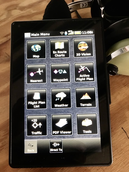
As soon as the 760 powers up, it shows the ubiquitous Garmin home screen, just like the company’s panel-mount navigators and the Garmin Pilot app.
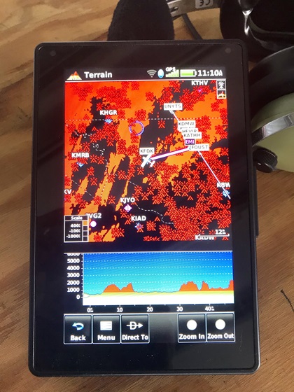
There are customizable profile, weight-and-balance, and document pages. But when linked to Wi-Fi in the FBO lobby, a quick glance at the map and weather pages shows current conditions across the entire country. Enter a flight plan and the terrain page will provide a color-coded map and profile view showing elevations along the way.
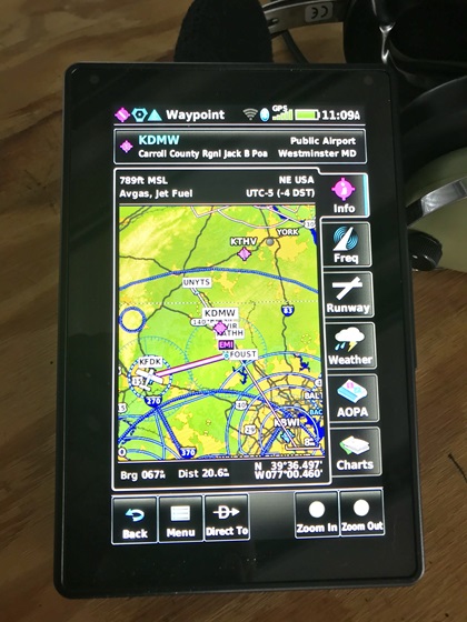
The waypoint page provides detailed information (including AOPA Airport Directory text) about airports, navaids, and services at each facility.
For IFR flying
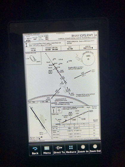
The 760 screen shows IFR arrival, approach, and departure procedures in just about the exact size as printed pages. But the pinch-zoom feature and high-resolution screen make even the smallest print readable.
Loading and activating them is a bit different from other Garmin devices, however, because the “procedures” (PROC) key is absent from the 760. Loading or activating IFR procedures is done on the Flight Plan page, a somewhat more cumbersome process that requires a few extra keystrokes.
Also, the familiar “activate vectors to final” (VTF) command is gone, and that’s a mixed bag. I always enjoyed the simplicity of VTF and made a habit of activating it at the earliest possible moment, even though doing so could also make waypoints other than the final approach fix disappear from the flight plan. The 760 allows pilots to fly directly to any fix on the approach, and then it will auto-sequence all the way to the runway. But I still miss the straight VTF magenta line that shows the extended centerline on the final approach course.
My one complaint about the approach plates was that the white airplane symbol lacked contrast and blended into the white background. Later, I realized I had been navigating with a VFR moving map before loading the approach. As soon as I switched to an IFR chart, the airplane symbol on the georeferenced approach plate switched to high-contrast magenta.
I commonly fly with the VFR map on IFR trips because I like knowing about the topography below. The 760 allows all sorts of aircraft symbols (low wing, high wing, multiengine, jet, helicopter), but all of them are white. Maybe it’s time to toss a few color options into the Setup menu.
For VFR flying
The high-resolution screen shows the moving map in brilliant color and detail—especially in full screen.
It comes with Garmin’s obstacle database and a detailed Terrain page, which is tremendously helpful in identifying potential routes through mountainous terrain. Those features were invaluable on a recent transcontinental trip in a backcountry airplane.
Somewhat counterintuitively, I particularly appreciate Garmin’s “3D Vision” screen during VFR flights. The 760 shows a forward-looking view of the airplane moving through a GPS-derived landscape. When connected via Bluetooth to a GDL ADS-B receiver with an air data attitude and heading reference system (ADAHRS), however, it can show an all-in-one attitude instrument (either full screen or split screen). That’s a potential lifesaver in haze, at night, during an inadvertent cloud encounter, or any other time pilots are at risk of spatial disorientation.
The moving map allows pilots to check airspace limits at the touch of a button. Garmin’s “Smart Airspace” feature can declutter the moving map and make relevant airspace more prominent as it gets nearer. It also can show TFRs when connected to an ADS-B receiver, and that’s a terrific backstop for VFR flying during an election year.
A common complaint among mid-Atlantic pilots, however, is that checking the dimensions of the Washington, D.C., and Baltimore Class B airspace is nearly impossible. All of it underlies the Washington, D.C., VFR speed restriction, so all the GPS tells you within 60 nautical miles is that special rules apply below 18,000 feet, and that’s not terribly useful.
No Zoom calls
 The 760 is an ideal size for a yoke or kneeboard mount, and it comes with a cigarette-lighter adapter that works in airplanes with either 12- or 24-volt electrical systems.
It’s a highly capable stand-alone GPS—but it gets much more powerful and clever when integrated with other Garmin equipment. When linked via Bluetooth or Wi-Fi to an ADS-B receiver, or Garmin panel-mount avionics, for example, the 760 can show weather, traffic, aircraft attitude, and other vital and timely information. When paired with SiriusXM Weather, the 760 can show cloud tops, freezing levels, lightning, and other advanced features.
The 760 comes with one free database update, and it took about one full hour to download it from the FlyGarmin website through the USB cable on a laptop. Garmin recommends charging the unit for four hours before flight, but it took less time than that to fully charge the internal battery with the wall charger that came with it.
Garmin says the 760 can operate about 4.5 hours on battery power although screen brightness, cabin temperature, and other factors can extend or shorten battery life.
The 760 has a bright, responsive, easy-to-read screen that efficiently uses almost all its available space. It’s much more rugged than an iPhone or an iPad, and it’s far less sensitive to heat, cold, and vibration—and the screen is less reflective in direct sunlight.
The 760 isn’t as versatile as an iPad. You can’t use a 760 to join a Zoom call, FaceTime with your kids, or write a Yelp review. But you can answer just about every conceivable aviation question that comes up during an IFR or VFR flight, and that’s plenty.
The best aviation products are solely aviation products. And even though this one looks and acts like a smartphone or a tablet, it’s a much more reliable tool for flying than any mass-market consumer product could ever be.


.jpg?mw=650&mh=366&as=1&hash=73D217D9DBE526082C1DAAD9CF28B5C7)