Career Pilot: Weather radar rules
Vital tool requires knowledge of its shortcomings
For example, a jet’s performance allows it to rapidly climb up through icing layers, making iced-up jets a rare occurrence. Even iced-up jets have reliable ways to shed it in the form of heated surfaces such as leading edges, engine inlets, windshields, and more. Another big advantage jets have is weather radar to avoid thunderstorms.
Weather radar has been around for decades and has been miniaturized enough to find a home in larger light general aviation airplanes since the 1970s. It provides a real-time image of the weather. Nexrad images that can be datalinked to in-cockpit displays represent a more recent technology that, although beneficial, is subject to a potentially hazardous lag from when the image was obtained to the time it is processed and reaches the instrument panel. While Nexrad datalink is a great tool, it is not good for getting up close and personal with thunderstorms. Radar is the way to go but it, too, has its limitations.
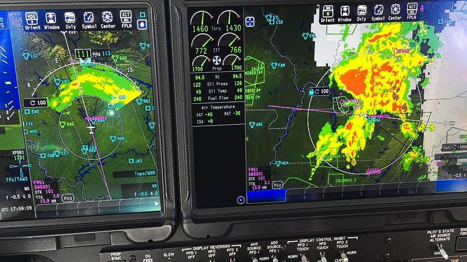
It’s smart to think of weather radar as a water detector. It only paints precipitation, and liquid precipitation reflects most effectively. Frozen precipitation such as snow and ice/hail may not even show up. Radar uses a receiver/transmitter. It transmits a beam of energy that reflects back to a receiver. This gets translated into an image on a screen. Radar paints land but not bodies of water. But didn’t I just say radar was a water detector? Land reflects energy back to the receiver whereas bodies of water bounce the transmitted energy off to infinity. Bodies of water show up as a blank return.
It’s smart to think of weather radar as a water detector. It only paints precipitation, and liquid precipitation reflects most effectively.Tilt control is the key to radar operation. Most modern radars have an automated tilt function but there are times when you wouldn’t want to use auto tilt. Those with older radars will have no choice but to manually operate the tilt function. Tilt points the radar beam upward or downward to analyze the precipitation. It works on the ground, too. Worried about that darkness off the end of the runway? Point your nose toward it, tilt up, and take a look.
Radar dish size is key to how well the system works. While GA airplanes have a dish the size of a dinner plate, an airliner’s nose can house a radar dish as big as a dinner table. The bigger the dish, the more energy it can transmit and receive. This translates to better detection and better ranging, and is one reason why airliners are far better suited to maneuver around thunderstorms. The radar in the Boeing 737 I fly can reliably paint weather 200 nautical miles ahead or more. In the Beechcraft Bonanza and Cessna P210 I used to fly, the small radar housed in a pod on the wing was only reliable to about 40 nm, depending on conditions. Light twins, turboprops, and corporate jets all house progressively larger dishes that can better sniff out storms.
Any radar is susceptible to a hazard known as attenuation or shadowing. This occurs when the radar’s energy gets absorbed by closer weather, effectively shadowing storms that lie further downrange. Shadowing has been fingered as a cause of several airplanes punching into thunderstorms and not coming out the other side. The 1977 crash of Southern Airways 242 comes to mind. In that crash, a radar shadow lured the pilots into the worst part of the storm, with rain and hail so heavy it snuffed out both engines of the DC–9 and leading to a forced landing with many fatalities.
Often it’s best when analyzing storms to range in and out to get an accurate idea of what you’re looking at. While looking at a storm 40 miles ahead in the 50-nm range selection, don’t forget to range out to the 100-nm setting to see what lies beyond—there could be a potential trap. Crescent shapes or feathered edges of cells could indicate shadowing, so tread carefully and cross-reference other sources for a fuller picture or ask ATC.
Often, pilot reports from other airplanes can provide a better picture. I remember flying into a southern Florida airport years ago with a big, fat red blob parked right on the final. It looked ugly, but we saw no lightning. We didn’t have a lightning detector such as a Stormscope on board. I asked the controller to get a pirep from the preceding aircraft who reported back, “heavy rain and a smooth ride,” indicating that this was just a strong rain cell with no convection—yet. His report was correct, and we got a free bug wash.
Like so many things in aviation, the key is realizing the limitations of your airplane and its equipment. Just because your light twin has radar, lightning detection, and a King-Kong-level Sirius/XM WX setup doesn’t mean you can challenge the weather that airliners can. Even with the superior radar, the pros get burned too.
Related Articles


