TAF or LAMP?
Numerical forecasting gets better


 Is this kind of bashing warranted?
It should come as no surprise that the National Weather Service (NWS) keeps track of its prediction accuracy—it’s called verification—and the agency’s performance is pretty good. But an Embry-Riddle Aeronautical University study revealed that TAFs missed low IFR (LIFR—ceilings below 500 feet and/or visibilities lower than one statute mile) predictions 44 percent of the time—when conditions actually turned out to be IFR or higher ceilings (ceilings at or above 1,000 feet and/or visibilities at or above three statute miles). Hmmm. An error rate like that can put a big crimp in your flight planning.
TAFs come out four times a day at six-hour intervals, and they are generated by forecasters at the nation’s 122 local NWS Weather Forecast Offices. These forecasters are very familiar with the weather patterns and quirks in their assigned regions, which is the main reason for our reliance on them for complying with the “1-2-3” rule set out in FAR Parts 91.167 and 91.169. These have to do with fuel requirements and alternate airport designations. If the forecast from one hour before to one hour after your estimated time of arrival at your destination airport is below a 2,000-foot ceiling or visibility below three statute miles, then you need to name an alternate. To name a qualified alternate, that airport’s forecast must be at least a ceiling of 600 feet and a visibility of two statute miles if it has a precision approach procedure; if it has a nonprecision approach procedure, forecast conditions must be for at least an 800-foot ceiling and two-mile visibility.
What if your destination and alternate don’t provide TAFs? That’s where the relevant FARs give you an out. Both FAR 91.167 and 91.169 give credit to “appropriate weather reports and forecasts, or a combination of them” for naming destinations and alternates. TAFs aren’t specifically mentioned, nor is the Graphical Forecast for Aviation (GFA) tool on the Aviation Weather Center website (aviationweather.gov), nor are the Model Output Statistics (MOS) forecasts found on ForeFlight and Garmin Pilot.
Nor are the Localized Aviation MOS Program’s (LAMP) forecast products. You can find these forecasts under the MOS products tabs on ForeFlight and Garmin Pilot. The LAMP program crunches meteorological data using supercomputers programmed for this, and it spits out forecasts for many, many airports (1,850 or so) not served by TAFs, which are published for 750 airports. LAMP updates its forecasts every hour, with most of its emphasis dwelling on recent ASOS reports, out to 25 hours, after which time another forecast model, the Global Forecast System MOS (GFS MOS), takes over.
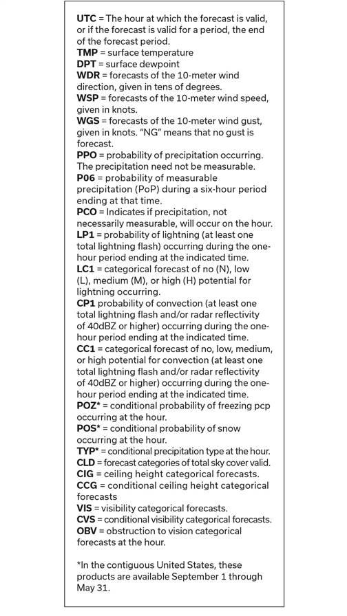
ForeFlight and Garmin Pilot make it easy to read their MOS products; they’re translated into plain English using abbreviations we all understand. But you’ll have to dig deeper and work a bit harder to make full use of an official LAMP alphanumeric message. We’ve published a sample message and its decoding legends so you can see what you’ll be dealing with when you call up LAMP.
Go to vlab.noaa.gov/web/mdl/point-lamp, click on the “station-based LAMP” menu bar, then click on the “LAMP text bulletin by state” or “LAMP bulletin by station” icons. Now you’re ready to select an airport by state. You’re most likely to be interested in things like wind direction (WDR), wind speed (WSP), cloud cover (CLD), and ceiling and visibility (CIG and VIS, respectively). But if you’re interested in lightning and convection potential, it’s also there—along with a lot of information about precipitation probabilities and types.
So which product will you trust? Bear in mind that predicting LIFR is tricky for both man and machine, and that point forecasts (clear calls or probabilities for specific locations) are the most challenging. TAFs, LAMP/MOS, and graphical forecasts are all well worth checking as part of your preflight planning, but once en route SiriusXM Aviation weather and FIS-B can take the prize for alerting you to any truly adverse weather that could encroach on your plans. Don’t forget flight service, ATC, or VFR advisories (aka flight following), any of which can issue late-breaking advice or warnings.


