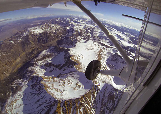
A NASA Jet Propulsion Laboratory Twin Otter is flying high above the mountain watersheds of California and Colorado, measuring snowpack that will account for 75 percent of the drinking water supply in those regions once it melts.
The missions began in April, and will continue through the end of the melting season, with the twin-engine turboprop and a crew of pilots and scientists cruising over mountains at altitudes ranging from 17,500 feet to 22,000 feet as high-precision sensors measure the depth of the snowpack, and the amount of light reflected from it. The data is key to predicting both the volume and timing of snow melt with accuracy not possible using satellites or limited ground observations.
“The Airborne Snow Observatory is on the cutting edge of snow remote-sensing science,” said Jared Entin, a program manager in the NASA Earth Science Division, in a news release. “Decision makers like power companies and water managers now are receiving these data, which may have immediate economic benefits.”
The technology promises to improve water management for 1.5 billion people worldwide who rely on melting snow for fresh water. The California Department of Water Resources is collaborating with NASA on a three-year demonstration mission that will include weekly flights (during the snow melt season) over the Tuolumne River Basin in California's Sierra Nevada, and monthly passes over Colorado's Uncompahgre River Basin. As the Otter cruises above the peaks, a laser ranging system (lidar) measures snow depth to an accuracy of four inches, while a spectrometer measures the light reflected—a property called albedo that is critical to forecasting the pace at which snowpack will melt. With this information in hand, scientists can calculate how much water will fill a given watershed, and when.
Water resource managers, farmers, hydroelectric plant operators, and many others living in dry regions need this information to make decisions about how the water is used. Currently, those decisions are made based in large part on a limited series of ground measurements, and estimates are far less accurate.
“The Airborne Snow Observatory is providing California water managers the first near-real-time, comprehensive determination of basin-wide snow water equivalent,” said Frank Gehrke, mission co-investigator and chief of the California Cooperative Snow Surveys Program for the California Department of Water Resources. “Integrated into models, these data will enhance the state's reservoir operations, permitting more efficient flood control, water supply management and hydroelectric power generation.”

Related Articles


