Garmin announces new portable aviation GPS
A GPS that looks (and acts) like a smartphone
Although the once-vibrant handheld GPS market has been nearly wiped out in this era of omnipresent smartphones and tablets, it’s not extinct. To adapt, however, Garmin has recast its new portable GPS in the image of a smartphone.
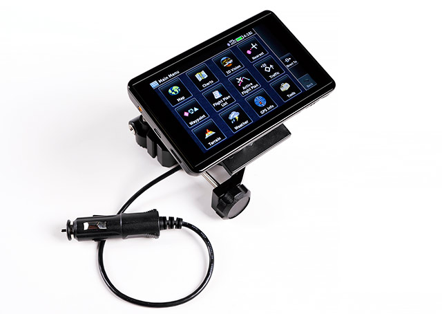
Garmin’s new aera 660 looks and acts so much like a smartphone that, when you open the box, you might think Amazon mixed up your order and errantly sent you a Samsung. The black touchscreen device is a bit bigger than an iPhone 6 but not as large as a 6 Plus. It has no outwardly identifying markings, and it’s only when you power it up that you’re greeted by the distinctive Garmin logo, and then the familiar main menu symbols.
In fact, the main menu is virtually identical to the Garmin Pilot app (or the panel-mount GTN 650/750).
Even though the 660 looks, feels, and acts like a smartphone, its frame and innards are much more robust. The 660 is built and tested for extreme heat, cold, vibration, and rapid pressure changes. It’s no coincidence that Garmin unveiled the 660 at the Helicopter Association International conference. This unit features a detailed obstacle database in which power lines are especially prominent, and its rugged construction was meant for shaky helos.
The 660 screen is readable in sunlight and has a six-hour battery. The biggest changes from its immediate predecessor, the aera 560, are the 660’s “capacitive” (not “resistive”) screen, and wireless connections. The 660 screen requires almost no screen pressure to activate, just like a smartphone. In turbulence, the unit is small enough that you can brace your thumb and middle finger on the sides to steady your hand, and touch with your index finger. (And like a smartphone, if you wear gloves, they’ve got to be a capacitive touchscreen variety or the screen won’t respond.)
Wireless connections allow 660 owners to update databases via Wi-Fi and avoid fooling with desktops, SD cards, and all those troublesome readers. Wireless connections also enable the 660 to communicate with Garmin’s GDL-39 3D ADS-B receiver and GTX 345 transponder for weather, traffic, and synthetic vision. Garmin also plans to offer the ability to transfer flight plans between the 660 and panel-mount avionics via FlightStream in the near future.
I took the 660 on a series of VFR and IFR flights and found it useful and versatile—especially when paired with an ADS-B receiver (which provides weather, traffic, TFRs, fuel prices, synthetic vision, and a G-meter).
When sport flying, the 660’s G-meter is a pleasant surprise. The round-dial representation shows up to six positive and three negative Gs, and it responds instantly with no discernible instrument lag. The synthetic vision picture also does an admirable job of retaining its orientation, even during mild aerobatic maneuvers.
VFR pilots can choose between Garmin’s proprietary maps or VFR sectionals, and users can select the level of detail they want (although helicopter-oriented obstacles and power lines are always visible). The Terrain page is a trustworthy friend, and pilots have the option of receiving aural warnings.
For IFR flying, the 660 shows low- and high-altitude en route charts as well as approach procedures. The relatively small screen makes it necessary to scroll and pinch-zoom to find details on approach procedures, a disadvantage compared to a larger iPad, iPad Mini, or Garmin 696/796 that can display an entire full-sized approach at once.
I wasn’t sure synthetic vision would be useful on the 660’s relatively small screen. But it comes through in rich resolution, especially in the vertical “portrait” format. There’s no flight path marker (green dot) as on panel-mounts such as the G500/600 or G1000. But mountains, lakes, rivers, and color-coded terrain features show up during cruise. On approach, runways become discernible at about five miles, the overlaid attitude indicator and slip/skid ball react fluidly, and an HSI with magenta GPS course guidance is extraordinarily precise. Tapes showing (geometric) altitude, ground speed, and ground track complete the syn-vis picture.
Without an attitude heading reference system connection, the 660 can show “3D Vision,” a graphical representation of an airplane moving over GPS-derived terrain contours. The limitation is that 3D Vision estimates the airplane’s bank angle (based on speed and turn rate) and provides no pitch information whatsoever.
Curiously, the 660 doesn’t show a standard PFD screen, and that would seem like a highly desirable intermediate step between synthetic and 3D vision.
Once you land, Safe Taxi charts show airport diagrams in detail and highlight potentially troublesome intersections. The airport diagrams even show the exact locations of particular FBOs and airport businesses.
A quick touch of one button gives you the option of switching between portrait and landscape orientations at any time, or mute nuisance aural warnings.
ADS-B weather and traffic are available on dedicated pages, and they show up together on moving maps. (But your airplane must be sending ADS-B Out signals in order for the 660 to get the full traffic picture.)
Garmin also provides extremely useful fuel price comparisons on the map, and good fuel deals are color coded so that they stand out conspicuously. On my first flight with the 660, I learned that avgas at a nearby airport was almost a dollar a gallon less than my home field, so the savings from a few well-informed fuel stops can go a long way toward paying for the 660.
For pilots who record their flights on Garmin VIRB video cameras, the 660 allows you to operate the camera remotely (a capability that’s also offered through the Garmin Pilot app).
In sum, I found the 660 to be extremely useful when flying in visual or instrument conditions.
By itself, it’s a terrific navigator that can answer just about any question a pilot might have about airspace, airport information, or terrain. When linked with an ADS-B receiver, it provides real-time weather and traffic information as well as money-saving fuel prices and TFRs. And wireless database updates are a big plus.
In IFR conditions, synthetic vision shows your surroundings at a glance—and that’s a great comfort. When paired via FlightStream with Garmin’s integrated panel-mount avionics, the 660 will work like the keypad on a flight management system—an option that, by itself, would cost many thousands of dollars in an FAA-certified avionics suite.
But the 660’s value is an open question.
The 660 sells for $849. Will pilots be willing to pay more for Garmin’s ruggedized, sunlight readable, aviation device than an iPad Mini or a smartphone that can fill many more functions on the ground? Will pilots value the reliability and ease of use of the 660 more than the ability to text, take selfies, or post to Facebook?
We’re all about to find out.

Related Articles


