Chart changes planned for traffic patterns, 'hot spots'
The group that modifies how symbols appear on aeronautical charts thinks a minor change to how nonstandard airport traffic patterns are indicated on sectional charts could have a major effect on safety.
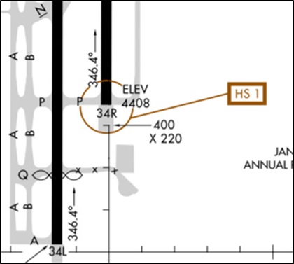
The Aeronautical Charting Meeting, held in October at AOPA headquarters in Frederick, Maryland, also agreed on the need to publish new airport hot spots in places where pilots have made mistakes picking where to touch down, and set a long-overdue update of a chart of the Grand Canyon.
Right traffic
When an airport uses a right-hand traffic pattern to one or more runways instead of standard left traffic, the letters RP appear in the information beneath the airport’s name on the chart. What follows the letters RP sometimes lacks clarity, however.
That’s pretty straightforward, but a few miles to the east is Brookhaven Airport, where the traffic flow has different rules. Here the letters RP are followed by an asterisk (*), not runway numbers. Looking up that notation style in the chart legend, a pilot learns that “special conditions exist.” The navigation chart’s legend refers you to the chart supplement publication to find out what the special conditions are.
In the airport remarks section of the chart supplement’s listing for Brookhaven as of Nov. 8, appears a note: “Gliders use rgt tfc pat for Rwy 24 and Rwy 33, gliders use left tfc pat for Rwy 06 and Rwy 15.”
In other words, at Brookhaven, gliders fly right traffic to Runways 24 and 33, and left traffic for the two reciprocals. Not stated—but inferred from usual practice at nontowered airports—is that other fixed-wing traffic flies standard left traffic for all runways.
Unfortunately, at airports where special conditions exist, charting has been inconsistent and can cause misunderstandings, according to a recommendation approved by the Aeronautical Charting Meeting at its October session at AOPA. The ACM is a public forum that meets twice a year and is “the primary method of adding and modifying charting specifications,” according to the FAA.
In a presentation to the ACM, Felipe Cocco, a New York City pilot who flies from Brookhaven and an interface designer, produced several examples of inconsistent right-traffic notation for airports on VFR charts. The inconsistencies mainly consisted of a subtle but critical feature: the varying placement and font of the asterisk associated with the letters RP.
In some cases, he noted, the position of the asterisk helps “lead pilots to an incorrect interpretation” that right traffic is required to all of an airport’s runways.
Cocco’s solution was modeled on an existing format already well known to pilots: notation for airport lighting.
Pilots learn that the airport-lighting symbol “*L” (with the asterisk preceding the letter and published in superscript) indicates that they should consult the airport’s chart supplement entry for details about the pilot-controlled lighting system.
Cocco urged standardizing airport right-traffic notation in a similar format, with the asterisk preceding the letters RP, rather than following RP, “to avoid pilots thinking that the asterisk is there in place of runway numbers.”
The ACM agreed with the recommendation. Some changes could appear as soon as next year, said Rune Duke, AOPA senior director of airspace, air traffic, and security, and AOPA’s representative to the ACM. However, much FAA internal documentation must be changed before the notation is fully distributed, including on navigation charts, and that could take several years, he said. In the meantime, pilots should understand that an asterisk appearing with charted information acts as a reminder to check for details in aeronautical publications.
Cocco encouraged anyone with a concern or an idea to submit a recommendation to the ACM.
“It is our duty as pilots to share our experiences so we can learn from one another, and the ACM is a terrific way to share your perspective with the entire flying community. By doing so, you could potentially make us all a little safer,” he said.

Landing on the wrong surface
The ACM approved other revisions including charting new hot spots at airports where pilots may be prone to errors in picking their landing spots. Cautionary notes are already published for “wrong surface” departures, and for runway-incursion hot spots, and charting so-called wrong surface landing hot spots could improve a pilot’s awareness of a landing risk, Duke said. A new FAA video highlights how pilots can prevent wrong surface landings.
Grand Canyon sightseeing
The ACM also had good news for Grand Canyon sightseeing pilots, noting an FAA announcement that it has accepted a joint request from AOPA and the National Park Service to improve the Grand Canyon Aeronautical Chart, not updated since 2001. A new version will be published in February 2019 and every three years, Duke said, adding that the FAA had issued a Safety Alert about the chart because of errors it contained.
“The new chart will be much easier to use. It will incorporate VFR waypoints navigable using GPS,” Duke said. “More important, the chart will be accurate and better maintained. We appreciate the FAA quickly moving on our recommendations and providing a better product for the flying public.”


