Aerostat to be tested as rural broadband internet source
Aeronautics and telecommunications technology may soon team up to expand broadband internet access in rural Indiana.
The Wabash Heartland Innovation Network (WHIN), a 10-county alliance, is spearheading an effort to add enhanced broadband access to its initiatives aimed at developing the region “into a global epicenter of digital agricultural and next-generation manufacturing.”
In addition to using traditional fixed structures such as towers for deploying broadband, RTO Wireless, of Framingham, Massachusetts, operates mobile and fixed “aerosites” that, from 1,500 to 4,000 feet above ground level, can reach beyond land-based line-of-sight signals.
“Aerostats have been used to maintain communications after natural disasters, and by the military, but this will be the first commercial broadband service provided by an aerostat in the country. Right here in Indiana,” nonprofit WHIN said in a news release that announced the start of testing last July.
AOPA supports the development of digital technology and expanded broadband access consistent with flight safety, so we were curious to learn more about the plan.
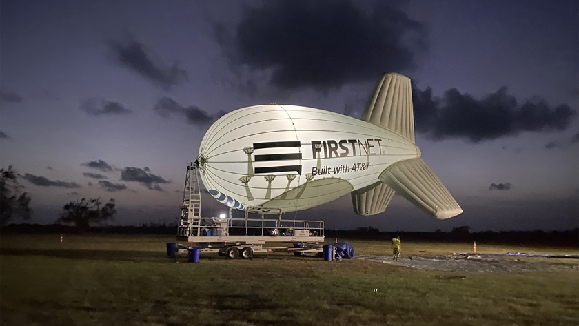
According to RTO Wireless CEO Steve Hubbard, who joined WHIN representatives; AOPA Great Lakes Regional Manager Kyle Lewis; and Jim McClay, AOPA director of airspace, air traffic, and security in a January 25 conference call, plans include grounding the 85-foot-long, 800-cubic-meter aerostat when instrument meteorological conditions prevail at the site located several miles west of White County Airport in Monticello.
For IFR purposes, the controlling agency for airspace in the vicinity of the nontowered airport, which has AWOS-3P weather reporting, is Grissom Air Reserve Base, 28 nautical miles to the east. The Chicago Air Route Traffic Control Center provides radar approach/departure control during off-hours.
Initial aerostat systems tests were scheduled for later in February.
In addition to determining a reliable method of ascertaining weather at the aerosite, several safety considerations for aviation were discussed. Aerial applicators treat crops in the vicinity, and local obstructions include wind turbines that rise several hundred feet above the ground in the area. Hubbard said discussions with the agricultural-industry pilots have produced a recommendation that the aerostat cable be flagged for improved visibility. AOPA also recommends that the cable be lighted if the aerostat is to fly at night.
The aerostat, which takes about 45 minutes to be extended to its flight altitude, can fly in winds up to 60 knots, and tolerate gusts up to 80 knots, Hubbard said. The aerostat will be ADS-B Out equipped, aiding its visibility to appropriately equipped aircraft.
Hubbard also described the vehicle’s “flight termination system,” which includes a valve that would be opened to slowly release helium from the aerostat that could be activated in an emergency, such as detachment from its tether. He also reviewed security precautions that will be taken at the aerosite.
McClay said that following FAA approval of a long-term waiver for operating the aerostat, adding it to navigation charts would occur during the next 56-day chart publication cycle. A similar example appears adjacent to the symbol for the Elizabeth City Coast Guard Air Station and Regional Airport on the Washington sectional chart.
Following the February tests, more operational trials were planned for March, with the first year of trials focusing on optimizing the equipment and signal specifications, the officials said.
Internet service providers have expressed interest in providing service using the aerosite, added Jason Tennenhouse, WHIN vice president of strategy and design.
The broadband internet service would be delivered in the 3550-3700 MHz Citizens Broadband Radio Service band, for which the Federal Communications Commission adopted rules for shared governmental and nongovernmental use in 2015.

Related Articles