FAA Weather Camera Network extends across the country
Where do you need a camera?
The FAA is expanding its Weather Camera Program to more locations across the country.

In a recent webinar, FAA officials and users from industry described the program that started in Alaska and recently expanded to Hawaii and other parts of the country. Currently they are inviting input on locations where pilots would like to see new camera installations added to increase access to weather information and improve aviation safety.
The FAA started the weather camera program in 1999, establishing a constellation of cameras looking in multiple directions at three airports in northern Alaska. Today, that system has grown to over 230 cameras installed and operated by the FAA in Alaska, and 11 in Hawaii. The system also provides imagery from "third party" camera locations, with significant concentrations of cameras in Colorado and Montana.
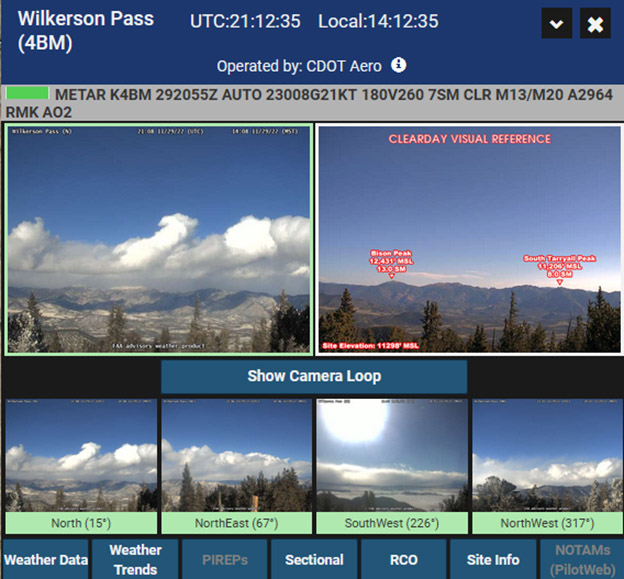
Weather information is delivered to pilots and other users via the FAA Weather Camera website, which shows images captured within the last 10 minutes displayed next to a "clear day" image. Annotated features indicate distance and elevation to provide a reference image users may compare to estimate visibility, cloud heights, or other weather phenomena. In locations where cameras are colocated with an AWOS or ASOS, the text METAR is also displayed, making a very powerful package for flight planning. Finally, the system provides a video-loop feature, allowing the display of the last six hours of imagery so pilots can evaluate trends.
While the FAA doesn't have resources to put cameras everywhere they might be needed, the agency supports a third-party hosting program where organizations, such as a state aeronautics department, may partner with it. In these cases, the third party installs and operates the cameras and the FAA hosts the images on its website, creating a one-stop-shopping location for pilots to obtain the imagery. AOPA weather surveys have shown that weather cameras have become an important preflight planning tool in areas where they are available. From our 2022 survey, the chief desire expressed by pilots was for cameras at more locations.
One purpose of the webinar, which may be viewed on You Tube, is to solicit feedback from users to identify locations where additional cameras are needed. Pilots are invited to submit their thoughts on where and why cameras are needed via a web form. The FAA is asking for input by December 20 for the first round of assessment. If you haven't checked out this source of weather information, I urge you to do so. Many times, a picture is truly worth more than a thousand words.


