Charting changes highlight mountain passes
First checkpoints charted in Alaska set stage
Flying through mountain passes can be tricky, particularly when the weather keeps you below ridge tops and confined to lower terrain. To help with crossing mountainous areas, major passes are charted as a visual aid on sectional charts. Sometimes, however, the pass is buried deep in a mountain range, and navigating to the pass can be a challenge.

Background
Passes are important points to identify when planning a flight through a mountainous area. A mountain pass is defined as both the highest terrain along a route through mountains and the lowest route that can be traveled between mountains. When approaching a pass, one is, by definition, flying into higher terrain. Once over the top of the pass, the route should be leading to lower elevations. Significant passes are marked on aeronautical charts with an hourglass symbol, including the name of the pass and the elevation at that location. Those details are important to evaluate during flight planning, when computing the minimum safe flight altitude required for your intended route. Once in flight, if a cloud layer overhead is restricting your ability to reach that altitude, you should consider this as a warning and turn around—while you still can—to execute your backup plan.
How easy is it to find a mountain pass? Some are in open valleys, with plenty of room to maneuver, and serve as little more than a point to note along the way, indicating that you might not need to climb higher to clear terrain. In other cases, however, these inflection points may be upwards of 100 miles from the edge of the mountain range. Following the correct river or stream leading to the pass may be difficult. In my experience, following a route upstream on a flight chart is a most challenging procedure. Many streams and rivers converge at acute angles, making it difficult at times to tell which valley is the one to follow. Sometimes, the widest valley doesn’t lead to the pass and it is important to identify which drainage will take you there. Having additional reference points on flight charts should make navigating to the pass a bit less stressful.

What’s new
AOPA led a national working group that examined issues associated with mountain passes, which resulted in a recent change allowing the use of VFR waypoints and checkpoints on flight charts to help locate commonly used mountain passes.
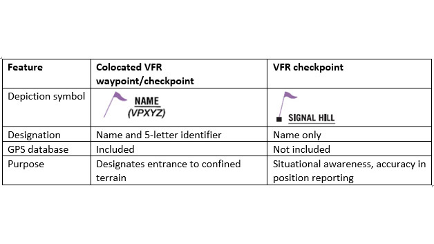
Two kinds of checkpoints are used, with slightly different elements. A collocated VFR waypoint/checkpoint is employed to designate entrance to confined terrain, such as a river valley or canyon. Depicted with the magenta flag symbol, these points have a name and a five-letter identifier (such as VPNUN) and may be found in a GPS database. Once inside confined terrain, however, only standard VFR checkpoints are used. These, also depicted with a magenta flag, have an identified pronounceable name, but lack an identifier and are not included in the GPS database.
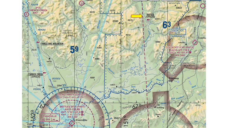
Bettles to Naqsralugiaq Pass
To illustrate how these features are used, examine a portion of the Fairbanks Sectional. Departing northbound from Bettles Airport, the low-terrain route leading to Naqsralugiaq Pass runs via the North Fork of the Koyukuk River. There are several rivers coming out of the Brooks Range that converge north of Bettles, so a collocated VFR waypoint/checkpoint is depicted at Rapids. This point is located before the entrance to confined terrain and allows pilots to double-check that they are indeed in the North Fork drainage. Another 40 miles upstream is a key location where the valley branches and pilots must bear to the right at the Upper North Fork VFR checkpoint to remain on the North Fork of the river. From firsthand experience, I can testify that it feels natural to want to continue north, straight ahead up the broader valley. Therefore it helps to have a checkpoint at this location to confirm where to make the turn into narrower terrain.
Once through Naqsralugiaq Pass, the valley follows the Itkillik River downstream to a collocated VFR waypoint/checkpoint at Itkillik Lake. The use of this symbol, with an associated identifier (VPMOP), signals the end of confined terrain for northbound traffic.
Not an IFR route
It is important to recognize that these checkpoints are selected to aid with visual navigation and are not designed for point-to-point IFR-style navigation. They provide no information regarding terrain clearance and are strictly visual reference points to increase situational awareness. The network of points also facilitates radio calls, using a common set of locations to increase awareness of traffic that may be nearby.
Charting other commonly used mountain passes
AOPA worked with the Alaska Airmen’s Association, Part 135 air taxi and government pilots, state and military agencies, and multiple branches of the FAA to provide this information on flight charts, leading to approval of the policy change. Since it is national in scope, it is now possible to apply collocated VFR waypoints/checkpoints and VFR checkpoints to other high-traffic mountain passes. AOPA created an issue brief that provides an overview of this process and includes information on how to request the addition of these features for high traffic passes in other parts of the country. The hope is that this effort will improve aviation safety when flying in mountainous areas.